Thursday, September 30, 2010

Pt Reyes National Seashore -- HOT and SUNNY!

Yes--it sounds like an oxymoron:  hot and sunny in the same title as Pt Reyes National Seashore.  But perhaps it was a chance to experience backpacking without frost on the tent at night!

After we got "spanked" by a cold front at Sequoia National Park, we returned to true Indian Summer weather in the Bay Area.  Alan obtained a backpacking permit for us at Pt Reyes and off we set -- determined to make the most of our final days of summer.

Although the signage says "wilderness" this backpacking trip was unique -- sites were pre-assigned and came complete with water, picnic table, trash pickup, and toilets! Very civilized backpacking!

We planned a 3 night trip:  out to Wildcat Beach; back inland to Glen Camp; and then finally up along the ridge to Sky Camp.

We have hiked many of the trails in Pt Reyes so we were struck by the variety and beauty all around us as we hiked.  Within a mile or so of the pounding Pacific surf we were deep into ancient forests complete with ferns, moss, lakes, and sparkling streams.


We began by going up the Bear Valley trail to the Great Divide Meadow for lunch.


You be the judge:  Along the trail, Alan and I practice our best "Bryan 2 Thumbs UP" poses.


All day we had beautiful views of the rocky cliffs and pounding surf.  The trail eventually switchbacked down to the coast and we camped in scrub within a few hundred yards of a bluff overlooking the ocean.  We watched the sunset and were lulled to sleep by the surf.  


This is Alamere Falls from the beach.


Day 2 we headed south along the coastal lakes trail stopping eventually at Bass Lake for lunch and a swim.  It sure was refreshing after hiking in that blazing sun!


Day 3:  After a night at Glen Camp (pretty unattractive dry, open camp) we were back on the trails--lush green foliage and occasional creeks.  

We took a dogleg back to the coast to have a snack at Arch Rock and then found Sky Trail.   Maybe the name says it all:  up to the sky and eventually Sky Camp.  
Alan and I were amazed at the clear views (some haze on the horizon) and absolutely NO WIND.  We got to Sky Camp in the early afternoon with plans to read in the shade.  HA.  


Our assigned site had not one speck of shade so we "camped" in a lush site for awhile.  But the cool shade was also inviting to every bug and critter with 2 wings within a few miles.  We took a quick rinse in the fresh spring that feds the horse trough.  Actually it was very refreshing.


There we were.  Sweating and waiting for the sun to go down, so we could pitch our tent, eat our mung bean dinner, go to sleep, wake up, eat granola breakfasts, and hike out.  The words popped out of my mouth:  Hey, let's skip ahead, have breakfast now and hike out.  It is only 3 miles or so (and downhill miles hardly count!).  We can be in the shower and out for dinner in San Rafael by 7:30pm.  I believe Alan was headed down the trail before the words were out of my mouth!   

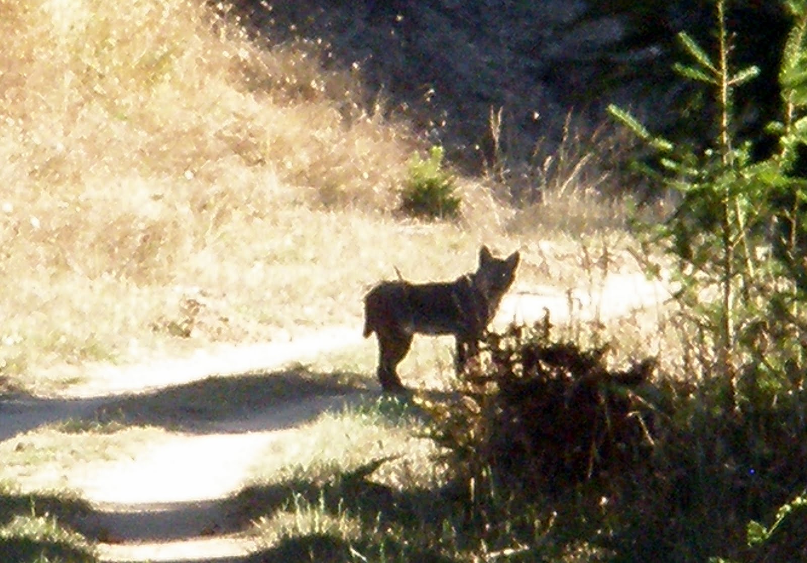
And so we were walking out just 2 hours after we had walked in to Sky Camp.    We spotted this bobcat by the trail.   He watched us and we watched him but eventually he headed into the trees.

None too soon but, all too soon, the packs were in the car.  The end of the trail and for us, the end of this year's backpacking season.

We are already thinking to summer 2011:  maybe a stroll up Mt Whitney, the Rae Lakes loop from the eastern side, and ????

It is fun to dream and watch wonderful things unfold.


Friday, September 24, 2010

A Perfect Day in San Francisco

We awoke from our Sequoia trip a bit grumpy and tired.  So what would we do to spark some adventure?  First we discussed all sorts of local options for camping -- and lucky for us we were able to get a permit for Pt Reyes and we leave Sunday for a 3 night backpacking trip.  AND the weather in the Bay Area has finally decided to be seasonal -- so we are enjoying Indian Summer conditions (warm with no fog).

So, we decided to ride our bikes to San Francisco today and take the ferry home.  We had been talking about this trip on and off during the summer -- and now the day was here.

And it was one of the most perfect days in San Francisco I can remember.  Gorgeous blue skies, warm but not hot temperatures, and almost no wind.

We rode to the City -- and found that every tourist in town had rented a bike and was also trying to cross the Bridge and see the sights.


Alan had a flat tire on the bridge! but thankfully he was able to change it with no problems.


We rode through the Presidio, along Lake Street (to see my old favorite first apartment building), through  Mountain Lake Park and then to Clement Street.  We had dim sum for lunch -- I think we were about the only non-Asians in the place.

Then down to Crissy Field and slowly over to the Ferry Building.  


We caught the Ferry back to Larkspur and then rode home.
Sure better than freezing in the mountains!

Sequoia National Park -- an unadventure

Shortly after Bryan committed to attend UC Davis this fall, Alan and I got busy planning a trip for late September.  We figured -- how can we miss Bryan if we go away on our own adventure?  So we settled on doing a 7 day, 6 night backpacking trip of the Rae Lakes in Kings Canyon National Park.  I called the park the week before our trip and discovered that the Sheep Fire in the area was severely impacting air quality and views.  Oops.  The ranger suggested we change plans and go further south to Sequoia National Park and hike out of the Mineral King area.

It is a long drive to these parks...down I-5 and across the Central Valley.  We left a day early so we would have time to hike a bit through several groves of Giant Sequoia trees.  They are massive and a photo does not really capture their size and stature in the forest.


On our drive through the park -- we saw a black sow and cub climbing a hill.  That was the highlight of the animal sightings on this trip.


The road to Mineral King is 25 miles long and takes 90 minutes to drive.  We finally arrived at a campground by the trail head, set up camp, found firewood, and had a pleasant evening.  We were at about 7,500 ft elevation.   In the morning, we picked up our permits and began the hike.  We knew the trip would include 2 passes close to 12,000 ft and a cold front was due in during the next 24 hours.

We set off -- slowly walking up Farewell Canyon towards our first night at Franklin Lake.


We had crystal blue skies and were hiking in shorts.  Franklin Lake was at about 10,000 ft elevation and about 5.5 miles away.  No way to go but UP.  We crossed several creeks (always a challenge for me) and made our way up through the forest.  The views were incredible.  In the 1960s, there were plans for a large ski resort in this valley--obviously it never materialized.


By the time we saw Franklin Lake, we were both ready to drop the packs.  The first day out with fully loaded packs (30 - 33 pounds) is always the hardest -- and a real incentive to eat up the snacks to lighten the load.  Franklin Lake was amazing.


We set up camp, filtered water, and explored the area.  No campfires allowed due to the elevation.  As soon as the sun went behind one of the peaks, the temperature began to plummet.  The best place to be -- in a mummy sleeping bag.  It was only 7pm!

We awoke to bright skies -- but the sun was a long time finding our tent and sure enough there was heavy frost on our tent and pack covers.  Looking west to Fresno -- lots of rolling, thick white clouds and while we discussed "the cold front" had breakfast and tried to figure out if we should go on or go back.  We had slept close to 12 hours; it was definitely colder; and we could tell that wind and clouds were on the way. I had absolutely no intention of hiking up another 2000 feet to cross Franklin Pass and NOT see the view.  The vote was 60-40 to head out and adventure elsewhere.  

Here are more pictures from the area.


There were ice patches on the trail down.  But going down was so much easier.  It was also amazing to watch the clouds roll in, the wind start to pick up, and to continually put on heavier clothing (gloves, hats, long underwear, long pants) as we hiked to lower elevations.  Temperature back at Mineral King at 1pm:  53 degrees.  As we drove down the hill we saw it go as low as 42 degrees at about 6000 feet elevation.  I can not imagine how cold we would have been at 10-12,000 feet.  So we learned what they mean by "a cold front."  It really means the wind is going to blow stink and temperatures are going to chill the bones.  

We then had the slow windy drive down the mountain to Visalia -- a real town of almost nothing south of Fresno.  We had average Mexican food and then drove 5 hours home.   It was quite late when we turned up our own "Sequoia Drive."   

A whole lot of driving for not very much fun -- some huge trees, a couple of campfires, a mountain lake, and seeing 2 bears.  Ummm.   Not every adventure matches the dream.  And when I do Rae Lakes next year -- I am going in from the east side (Onion Valley).  

Loving Mexico!

All summer long we continue to prepare for our trip to Magic -- now currently on the hard in Guaymas, Mexico during hurricane season.   Boat owners can apply for a Ten Year Import permit from the government -- this allows the boat to stay for an extended period of time in Mexico and offers some advantages on bringing in parts and gear.

In 2001 we also obtained a similar permit for Silhouette.  At that time, the paperwork dance was a bit tedious -- not hard in any way, just a slog.  Here was the process:
1.  Go to Aduna (customs) in Old Town Mazatlan to pick up the forms.  1 round trip bus ride.
2.  Back to the boat to find all the numbers & fill out the forms.
3.  Return to Aduna the next day -- the customs director was not available.  2nd round trip bus ride.
4.  Return AGAIN the following day -- the customs director instructed a junior agent to help us.  3rd round trip bus ride.
5.  Alan and the agent leave for the boat -- via bus trip number 4 -- taxis were "too expensive".
6.  Dinghy to the boat to check the numbers on the engine and registration paper work matched the completed Aduna forms.
7.  Then return to Aduna to get the import papers signed by the director.  Bus trip number 5.
8.  Alan walked to the bank to pay for the permit -- approximately $12.00 USD.
9.  Alan then took the receipt back to Aduna to pick up the final signed papers.  Back to the boat on bus trip number 6.

WHEW.  Three days, 6 bus rides and finally permit in hand.

FAST FORWARD to 2010.  We have bought Magic and with the bill of sale in hand, we apply for Coast Guard Documentation.  This takes about 6 weeks; can't be done on line; and oh joy -- gets to be done every year.  Maybe the Coast Guard could take a lesson from this new Mexican process.

1.  With the CG documentation papers in hand, go on-line, and find the form for the Ten Year Import Permit.
2.  Fill it out and hit submit button.
3.  48 hours later, DHL delivers the permit to our door!
4.  Sign the permit; scan the signed permit, passport, and documentation papers.
5.  Email this back to Aduna.

DONE!!

The funniest part of the story -- DHL is notorious among cruisers as the shipping company to avoid using in Mexico.  Everything gets lost somewhere.  So here comes our permit via DHL.

I guess times are changing.

At this point we are totally done with the paper work:  bill of sale, Coast Guard documentation, 10 year import permit, insurance on Magic, and car insurance for our trip.

UC DAVIS -- Go Aggies!

September 18 we dropped Bryan off at UC Davis.   This has been a key date in all our summer plans and schedules and now it has come and gone.

It is one of those bittersweet moments for a parent.  I am totally thrilled Bryan will be attending such a fine school.  But it is also the end of the days when he is home most of the time and he cheers up our dinner table and house with his music, activities, and friends.  And Bryan helps us get through the weekly trivia challenge in the Pacific Sun!

We packed up the car after breakfast and by lunchtime we were in Davis.  We had lunch at the Crepevine Restaurant and then moved into the dorm.   We picked up his pre-ordered text books, found an ethernet cable, and did a quick run to Target.  He was settled in and ready to be on his own.


One of his good friends is also a new Aggie -- here Sky and Bryan are getting ready to embrace a new phase of life.


It was time for us to leave.  We miss him.

Circumambulating Mt Yogelsang -- Yosemite

Circumambulating -- sounds like a mouth full, but really it just means to walk around something.  And yes, Mt Yogelsang is a high peak in Yosemite National Park in the Sierra Mountains near Tuolumne Meadows.  So we agreed on a family vacation -- going very slowly around Mt Yogelsang.

We drove up early to Tuolumne Meadows to get acclimated to the 10,000 foot altitude.  We spent one night in the backpacker's campground and then set off to do (we thought) 5 nights on the trail.  Our plan to go out the Lyell Canyon and back via Cathedral Peak changed almost instantly when we all realized that was WAY TOO much hiking and not enough time relishing the mountain and lake scenery.  So we slowed down and revised our itinerary after several family meetings perched on granite rocks.  We agreed on a 4 night loop exiting Rafferty Creek.

For me, this trip was a dream hike.   I have always wanted to hike along the John Muir Trail and Pacific Crest Trail.  The weather was the best -- warm sunny days and freezing nights.  But like magic, my sleeping bag was as good as advertised.  Warm and comfy all night long.  


Here Bryan and Alan are relaxing along the Lyell Fork of the Tuolumne River during a lunch break.  Day 1 was mostly level -- and rocks, water,  trees, and blue sky in view everywhere.


We spent our first night in a meadow near Ireland Creek.  We had left the Tuolumne River in late afternoon and had begun the climb UP so typical of the Sierras.  The next morning, Alan is up early and checking out the heavy morning frost on the tent.  But in a bit -- after we had tea and the sun dried the tent, we packed up and walked on.

Day 2 was filled with views -- especially looking west and seeing Mt Yogelsang ahead.  Along the trail we had views of mountains and trees seemingly growing out of granite.  This is Bryan leading our way.  We passed the High Sierra Camp at Yogelsang and then began the final climb of the day.


This was the view from the top.  We could finally begin walking down!


At the bottom of the descent, Bryan spied a flat area tucked under a few trees.  "Looks like a campsite!"  Pretty soon we had the tents up and Alan and Bryan were into a game of cards.

Our meals on the trail are fairly simple -- granola or oatmeal for breakfast; peanut butter & jelly (or nutella) on tortillas for lunch; and a precooked, dehydrated entree for dinner.  We have a dehydrator at home and so I can cook dinner, dehydrate it, and it packs in a small ziplock bag.  Rehydrating it means boiling a cup of water, dumping in the meal, cooking for a few minutes and then ENJOY.  Of course, any meal at this point would be fabulous.


Day 3 had a bit of everything.   We walked generally downhill along (or above) the Lewis Creek.  The Creek grew in size through out the day as smaller creeks flowed in.  We had expected more meadow like spaces but found mostly canyons and rock slabs.  I guess we learned that topo maps with a bit of detail can be more helpful than our large scale "park on a page" version!

We took a side trip to Bernice Lake -- oh my was this a fabulous place and I could have easily spent a day exploring above and around here.  Too soon back to the trail though!

We had a view of the back side of Half Dome.  I had never seen this side and again -- every step along the trail brought new views and angles to appreciate the spectacular scenery and light of Yosemite.


Day 3 ended with a climb.  Up of course -- and all the way to Babcock Lake.  We had originally planned to camp at the bottom of the climb, but found the space too cramped and close to the creek.  So we fortified ourselves with energy shotblocks (they taste better than they sound) and UP UP UP we went.  Bryan led our family -- and we kept looking at the dome ahead and trying to figure where the trail was leading.  

When we saw the sign for Babcock Lake -- we had a great feeling of WE MADE IT!


 We were camping that night at a low enough elevation to have a fire as long as it was in an existing fire ring.  Believe me I found the best camp site at the lake -- and an existing fire ring.  We stayed up (at least as long as our firewood lasted) to watch the stars and Milky Way.


Day 4 -- crossing a creek on our way to Emeric Lake for lunch and then along Emeric Creek to Brooks Lake.  Another day of sun, mountains, granite, trees, and the trail.


Alan and Bryan walking along.


A Yosemite escalator -- built by the CCC in the 30s.

We mused about who would be on a Mt Yosemite like Mt Rushmore "Wall of Fame."  Of course, John Muir, Ansel Adams, the CCC trailbuilders, Phil Frank (for fur and loafing in Yosemite), and the search and rescue teams.   It is good to remember how these known and unknown individuals have contributed to so much enjoyment by so many.  We are grateful to them.


Our campsite the last night by Brooks Lake.


We could not have legal fires due to the altitude.  But at our campsite we found this perfect "mini" ring and twig pile left by a previous camper.  We had a good laugh!!


Our campsite at Brooks Lake.  Every night we camped without anyone else nearby.  We had expected to share sites as it was a busy weekend (Labor Day) but found the solitude and quiet to be a special treat.


Hiking out on Day 5 gave us our last view of Mt Yogelsang and surrounding peaks.  We had a goal of getting to Tuolumne Meadows by lunch for a meal at the Meadow Grill.


We headed out along the Rafferty Creek.  Again views in all directions, and slowly Tuolumne Meadows unfolded ahead of us.


Waiting for Mom and Dad at the trail juncture.


End of the trail.   We circumambulated Mt Yogelsang.  Everyone is smiling!