Down from the mountains we drove...getting warmer, drier, and dustier as the miles flew by. Yeah, it was a scenic road but it didn't come close to the beauty of the Cascades.
Our goal was Lake Roosevelt NRA -- and it was a sorry, dusty, buggy, noisy campground that we found. I guess if you have a power boat and want a place to launch your boat and drive fast on the water -- this could be your place.
A nearby lumber plant was in operation round the clock...funny we didn't notice the noise in the afternoon. Yuck.
We were up and out of there at first light. On to Spokane and a night in a hotel. City Lights.
And a place to get the car locks fixed -- they are beginning to behave as if they have minds of their own: lock, unlock, lock.... We don't want to find ourselves locked out!
Wednesday, August 29, 2012
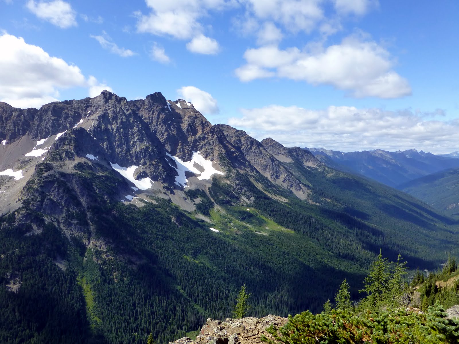
Windy Pass on the PCT
The wildflowers were stunning and I had fun playing with my new camera.
For absolute sure, I'm coming back to hike more on the PCT in Washington.
The hike over, we had to drive DOWN that narly road. And from there we continued east to Loup Loup Campground.
 |
| Another bit of wildlife |
 |
| Alpine meadows, Trees, Flowers, Snowy Peaks....what a morning walk |

 |
| A bit of mining history -- some claims are still being working in this area |
 |
| Looking back at Azurite Peak and our first hike |
 |
| Columbine |
 |
Slater Peak...The Top of the World
The next day, we hung in the campground to recover from our epic hike to GrassHopper Peak. The temperatures were warming; the winds abating. The on site ranger suggested we drive 3 more miles up that tortuous road and hike the final quarter mile to the top of Slater Peak.
Slater Peak is a now abandoned fire lookout station offering 360 degree views of the Northern Cascades, Pasayten Wilderness, and Okanogan-Wenatchee Forests. The peak is a flat top -- courtesy of the cold war in the 50s when the last 100 feet was blasted off to make a radar station for those pesky planes that never arrived. Anyway I'm sure the US guys had fun doing the munitions practice to blow the top off that hill.
As the weather system had blown through we were treated to stunning clear blue skies and breath taking views all the way to Mt Baker (northeast of Seattle). Views north to Canada. Views east down the long deep valleys of the Pasayten Wilderness. Every where, glaciers glistening in the sun.
We walked around the top of the peak, and felt indeed to be "on top of the world."
It was one of my favorite moments, but Alan thinks it was too easy a hike to warrant "hike of the trip" awards.


 |


To GrassHopper Pass and Beyond
Finally warm enough to imagine a hike, we left our campground at Hart's Pass in hats, gloves, jackets, and anything else we could wear. I totally don't get the folks up there in flip flops and T-shirts. The Pacific Crest Trail goes right through the Hart's Pass campground and one can day hike north towards Canada (about 35 miles) or south towards Rainy Pass (about 35 miles). Both directions offer stunning views as the trail follows ridge lines and traverses both high alpine meadows and forests.
We agreed to head south to GrassHopper Pass for views of Azurite Peak and Mt Ballard. WOW.
Around every turn and twist; after each ridge line and forest -- there were views of peaks, glaciers, waterfalls, lakes, snowpacks, and creeks. And as the day progressed, the gray gave way to blue, crisp sky.
During our lunch break on the shoulder of Tatie Peak, Alan looked out and said "there's a bear!" I grabbed my camera and took a couple of quick shots before the bear turned and ran into the woods. the bear was a bit away from us -- but I hope these pictures capture the thrill we felt. A Bear!
And then to make GrassHopper Pass and sit in silence with the beauty of the Peaks and Glaciers...well, the 15 mile day was so worth it.
 |
| The PCT crosses alpine meadows and clings to ridge tops in this section. See Alan?? |
 |
| Mt Ballard |
 |
| Alpine lakes and long valleys |
 |
| BEAR! |
 |
| Mountains and Snow |
 |
| Mountains and Snow |
 |
| Blue Skies |
Okanogan National Forest/Hart's Pass
We hiked out from Thunder Creek and headed east....spending a night in Kkipchick Campground. Then up and on the road -- determined to get to the Forest Service office in Winthrop. They would advise on current conditions for our next planned adventure up to Oval Lakes, near Twisp. The creeks were still running high & I am not at all keen on any creek crossings .... so we needed a new plan.
The Forest Service ranger suggested that rather than HIKE to high elevation we DRIVE up there and day hike or back pack in more "level" country. Now that was a concept we both eagerly embraced! The entry ticket was about 10 miles of a 1 lane, gravel, washboard road taking us to Hart's Pass (6,400 feet) from Winthrop (2,000 feet). All told it took us more than an hour of slow going, at times using our 4 wheel drive capability.
We arrived and found a campsite -- just as the wind was really starting to pick up and gray clouds filled the sky. We had expected cooler temps with a change in the weather, but we totally did not plan on the honking wind. The tent was up, the car camping sleeping bags unpacked, and a quick dinner before trying to get warm in the tent at 7:30pm. Even in our sleeping bags with long underwear and hats on -- we were cold. So brave Alan decided to make a dash to the car and pull out our down backpacking bags -- good for zero degree weather. I was grateful when he returned and I put the down bag inside the lighter weight bag....finally feeling warm. In the middle of the night, Alan got up and peeked outside: SNOW FLAKES! Oh my, a bit more weather than we counted on.
But finally morning came, and eventually the sun warmed us up. Enough to think about a day hike along the Pacific Crest Trail.
 |
| A Fabulous Trail |
North Cascades National Park
We left Seattle with a change in the weather -- gray clouds moved in and we headed east. It was Sunday and all the campgrounds empty out as weekend recreation winds down. We were headed to the east side of the Northern Cascades, but as we passed the North Cascades National Park Visitor Sign we were intrigued enough to stop in the Visitor Center.
And just like that we had a new plan!! We spent one night camping near Diablo Lake (Colonial Creek Campground) and then headed up Thunder Creek for a backpacking trip. Thunder Creek should really be named Thunder River as the snow melt from multiple glaciers cascades down the steep cliffs and mountains and rushes out to the Diablo Lake.
The hike was incredible and always in the background was the sound of Thunder Creek. Our destination campground, Junction, was across the valley from the Klawatti Glacier so we were rewarded with stunning views of jagged peaks, tumbling waterfalls, and thick snowpacks.

 |
| Great Sign, Cute Couple |
 |
| Jagged Peaks, Snow Pack, Tall Evergreen Trees. Everywhere, |
 |
| Glacier melt cascading into Thunder River, er Thunder Creek. LOUD |

 |
| Snowy Peak |
 |
| Glacier & Mountains |
 |
 |
| Jagged Peaks. Cascading Water. Repeated Everywhere |
 |
| Thunder Creek runs green due to glacial flour.... |
 |
| Diablo Lake with Mt Davis. Green water from glacial flour |
Tuesday, August 28, 2012
Good Bye to Seattle
We had a few last wonderful days in Seattle.
Bainbridge Island is a short, 30 minute ferry ride from Seattle so we took our bikes across to ride the Chilly, Hilly Route. It was Hilly but not so Chilly. A good work out for the legs; many fine views; and sun warmed blackberries.
Cruising friends Jill & Brent treated us to a sunset sail on their sweet J-37 sv Cayusa followed by a delicious dinner. We yacked away in the cockpit just like old times in Mexico! The years just flew by.
We also enjoyed a lazy Saturday with David while Monica was involved with the final summer production of the play Hansel & Gretel.
And then...off we went headed east....
Saturday, August 18, 2012
Bye, Bye California.....Welcome to Washington
It is a bit of a challenge to answer the question: where are you from? I wish the question came with multiple choice answers:
a. LaPaz, Mexico (Magic's current homeport)
b. Davis, California (a storage unit, a car registration, a driver's license)
c. Green Cove Springs, FL (a mailing address)
d. All of the above
e. Some of the above
So, let's add another place to the list: Seattle, Washington.
And Seattle is our current and favorite answer because this week we became residents of Washington complete with WA car registration, WA driver's license, WA car insurance, and WA Voter Registration. Bye, Bye California!
The bottom line for us to become WA residents is NO STATE INCOME tax! California has a pretty hefty income tax and we went looking for options and settled on the Evergreen State.
 |
| The Monty Gets a New Number |
Wednesday, August 15, 2012
Take Me Out to the BallGame, Take Me Out
to the Park.....Buy me some garlic fries & a veggie dog....
David scored great box seats at Safeco Field for a Seattle Mariners vs Tampa Bay baseball game. We cheered with all the fans but Tampa Bay won 4-1. Good Fun!
David scored great box seats at Safeco Field for a Seattle Mariners vs Tampa Bay baseball game. We cheered with all the fans but Tampa Bay won 4-1. Good Fun!
 |
| A Warm & Clear Night in Seattle |
 |
| PLAY BALL |
 |
| Fans! |
Sunday, August 12, 2012
Seattle
Hello Seattle -- we will be in town for a week or so staying with David and Monica.
David treated us to a tour of his new work site: the Gates Foundation!! WOW!! What a fabulous complex. You can find the Foundation on Google and do a virtual tour and learn about their mission.
It was a thrill to see the place and meet David's co-workers. AND get to eat in the cafeteria -- not just any cafeteria I promise you. Catered by Bon Appetit & subsidized by the Foundation -- it was a new way to visualize corporate life.
 |
| David |
The Enchanted Valley--Olympic National Park
We left Portland with a fabulous forecast for the Olympic National Park: sunny and no rain. The west side of the Park is a series of temperate rain forests and I was not interested in camping in any place that has RAIN in the title.
We arrived at Lake Quinault and quickly found a campsite with a lake view. When we talked to the ranger, she suggested a 30 mile round trip backpacking trip up the Enchanted Valley to the Enchanted Meadow. The trail follows the Quinault River and slowly climbs from 400 foot elevation to 2000 foot elevation through miles of temperate rain forest: mosses, lichens, mushrooms, ferns, HUGE trees, thimbleberries & huckleberries, and plenty of mosquitos. And, the end of the valley trail one arrives in the Enchanted Meadows to cliffs soaring another 2000 feet into the air and waterfalls fed by glacier melt. Some call the place a mini Yosemite!
We did the hike over 3 days: the weather was pretty fine; the heavy fog in the mornings gave us a sense of a wet and damp forest. The river roared along with beautiful pools of aquamarine blue. The trail was well maintained with bridges as needed and stream crossings on logs or rocks. At several campsites along the river there were installed bear wires.
It was a totally fabulous experience!!
 |
| Another National Park! |
 |
| Quinault River--glacier fed so COLD! |
 |
| Arriving in the Meadow & the chalet used only by the seasonal Park Ranger |
 |
| 4000 foot peaks + glaciers + water falls |
 |
| Anderson Glacier |
 |
| Foot Bridge across the River |
 |
| Great Views in the Valley |
 |
| Forest Walk |
 |
| Dense Canopy |
 |
| Quinault River |
Portland
We spent 2 days in Portland and packed it full with food carts, Powell's book store, and sales tax free shopping. We also met Sara -- the daughter of Caroline & Reed. What a sweetie!!
Too soon we were on the road again!
Too soon we were on the road again!
Saturday, August 4, 2012
Silver Falls State Park
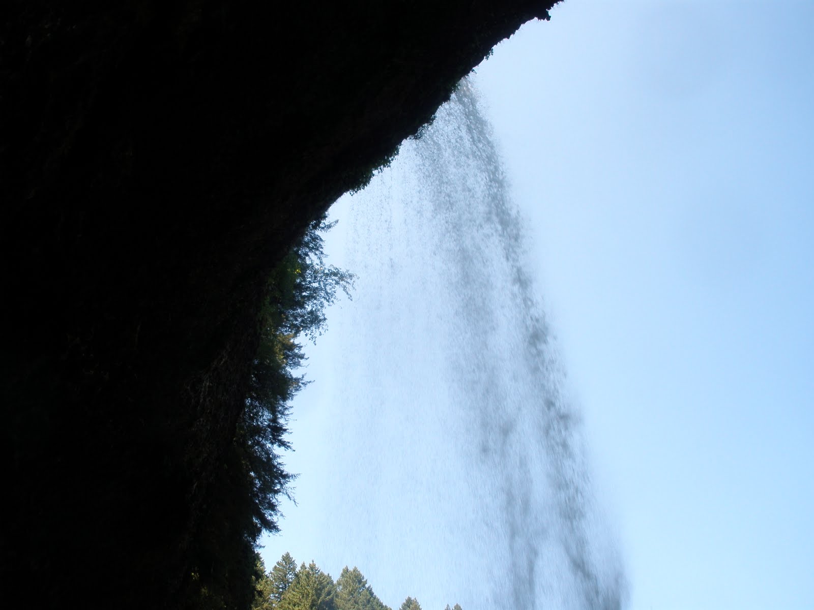
This area of Oregon is dominated by volcanic landscape features: snowy peaks and remnant lava flows. At Silver Falls State Park the 2 merge to create a series of waterfalls along the 2 forks of the Silver Creek. Plenty of water keeps the falls full -- and the lava flows create a series of stepping stone falls. And between some of the flows there is old sedimentary layers that have eroded so one can walk BEHIND the falls. And not like the Maid of the Mist stuff of Niagara Falls -- the trail goes behind several falls!
Along the 2 forks of the creek there are a series of 10 water falls. The trails are from the CCC and WPA era -- rough rock retaining walls, stairs, and gravel trails along the creek. The area is a tropical rain forest and so lush growth and 2nd growth trees crowded the trail.
Along the 2 forks of the creek there are a series of 10 water falls. The trails are from the CCC and WPA era -- rough rock retaining walls, stairs, and gravel trails along the creek. The area is a tropical rain forest and so lush growth and 2nd growth trees crowded the trail.
 |
| One of the Water Falls |
 |
| Silver Creek |
 |
| Another Falls |
 |
| The Trail through the Woods |
 |
| Crossing the Creek |
 |
| Behind the Falls! |
 |
| Behind the Falls |
 |
| WATER |
 |
| Another Water Fall |
Subscribe to:
Posts (Atom)